


JOIN US WHATSAPP CLICK HERE
JOIN US TELEGRAM CLICK HERE
SOLVING GEOGRAPHY – NECTA 2011
ANSWERS
1.
i |
ii |
iii |
iv |
v |
vi |
vii |
viii |
ix |
x |
B |
B |
C |
C |
D |
B |
C |
D |
D |
D |
2.
i |
ii |
iii |
iv |
v |
G |
J |
I |
A |
H |
3. The Components of the
Soil
Soil
Soil is the top layer of the earth’s
surface in which plants can grow, consisting of rock and mineral particles
mixed with decayed organic matter and having the capability of retaining water.
surface in which plants can grow, consisting of rock and mineral particles
mixed with decayed organic matter and having the capability of retaining water.
 |
| Soil |
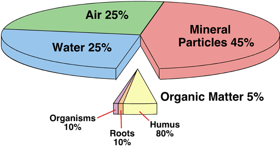
Soil is made up of the following components; organic matter
(humus), inorganic matter (minerals), soil water and soil air.
i) Organic Matter
This forms 5% of the total volume of soil and is made up of plant
and animal remains (humus). This forms humus as a result of decomposition of
animals and plant remains.
and animal remains (humus). This forms humus as a result of decomposition of
animals and plant remains.
ii) Inorganic Matter
This forms 45% of the total volume and is made up of minerals from
the parent rock. Minerals constitute several nutrients which are needed by
plants.Minerals include silicon, iron, calcium, magnesium, copper, lead,
nitrogen, phosphorous, sulpher, manganese, zinc, potassium and vanadium.
the parent rock. Minerals constitute several nutrients which are needed by
plants.Minerals include silicon, iron, calcium, magnesium, copper, lead,
nitrogen, phosphorous, sulpher, manganese, zinc, potassium and vanadium.
iii) Soil Water
Forms 25% of the total volume and it is one of the most important
soil components. It is derived essentially from rainfall especially from infiltration
and through flow.
soil components. It is derived essentially from rainfall especially from infiltration
and through flow.
iv) Soil Air
It forms 25% of the total volume. It
consists of the soil atmosphere from which plants and soil organisms obtain
oxygen for their metabolism and dispose of carbon dioxide and other gases.
consists of the soil atmosphere from which plants and soil organisms obtain
oxygen for their metabolism and dispose of carbon dioxide and other gases.
 |
| The Components of Soil |
4. (a) SIMPLE BAR GRAPH PRESENT THE ENROLMENT OF FORM ONE STUDENTS AT MJI MPYA SECONDARY SCHOOL

(b) 2006 has the highest number of students enrolment of form one students at mji mpya secondary school by 220students, then students enrolment started to decrease to 200 students in 2007 to 150 students in 2008, also it started to increase in 2009 by 180 students and in 2010 by 205 students.
(c) Advantages of simple bar graph
(i) It is simple to construct, read and interpret.
(ii) It has a good visual impression
(ii) It can be used to compare how the amount of an item varies from time to time.
5. (a) hypothesis formulation refer to an assumption used on what one expects to find out in the field It can be either true or false or Hypothesis is a prediction of outcome of the results. It is the statement of expected results.
(b) The following are the four (4) importance of hypothesis in research.
(i) A hypothesis ensures the entire research process remains scientific and reliable, following the principles of deduction
(ii) Hypothesis makes a research activity to the point and destination
(iii) Hypothesis select required relevant materials.
(iv) Hypothesis develop research technique
6. Survey is the process of observing and measuring in order to determine distance, position, boundaries and elevation of physical features on the land.
The following are the significance of survey in Tanzania.
(i) It helps in determine distance between various points on the ground
(ii) It helps to determine heights on the ground
(iii) It helps to determine angles on the ground
(iv) It helps in determine areas of plots of land
(v) It helps to take ground measurements for construction of various structure E.g roads, buildings e.t.c
(vi) Leveling survey helps to determine level of sloped ground
(vii) It helps to determine for sight intermediate and back sight of various points on the ground especial sloped land.
(viii) Survey is help in taking measurements to some areas where underground structure to be constructed E.g. pipe line, underground canal etc.
7. (a) AREA COVERED BY SWAMPS
calculating area using the square method
(i) Count the full square covered by lake Tanganyika on a map
Full square= 2
(ii) Also count half square covered by Tanganyika on a map and divide it by 2
Half square = 38÷2
Half square=19
(iii) Add full square and half square result obtained by divided half square by 2
2+19=21
(iv) Convert map area into actual area
Scale =1:50000, this means 1cm = 1/2 km
Use this scale to calculate area covered by swamps ( 1cm=1/2km)
Square both side 1cm=1/2km to get relationship between cm and km in square unit.
(1cm) square= (1/2) square
1cm square = 0.25km square
(v) find area of one square on the map.
To find the area of one square covered by swamps on the map, take a rule and measure the width multiply by itself.
Area of square = wxw
W= 2 so
A= 2×2
Area of one square on a map = 4 cm square
(vi) find the area covered by swamps
1cm square =0.25 km square
4cm square = x
Cross multiplication
1xX= 4x 0.25
X= 1kmsquare
Convert 21 square into kilometre square
21x1km square= 21 km square
Therefore Area covered by swamps = 21km square.
(b) natural vegetation found on a map are scrubs, thickest and tree swamps and distributed as follow
(i) Tree swamps occur near soda river on a map
(ii) Thickest occur eastern part of the map
(iii) Scrubs occur in all part on the map
(c) To measure the distance of river Ng’hulu from grid reference 625496 to grid reference
700522 using a sheet of paper.
700522 using a sheet of paper.
By using a piece of paper the map distance of river Ng’hulu from grid reference 625496 to grid reference 700522 is 20.5cm.
Scale on map = 1:50000
Change. 1:50000 into kilometres.
1km = 100000cm
X = 50000cm
100000x = 50000×1
x = 50000/100000
x =1/2 km (one a half)
So. 1Cm = 1/2 km
20.5= X
X=20.5x 1/2
X=10.25 km
Therefore distance of river Ng’hulu from grid reference 625496 to grid reference
700522 is 10.25 km
700522 is 10.25 km
(d) Three ways which have been used to represent relief in the area are
(i) Latitude.
(ii) Grid references.
(iii) Contour line.
(e) The following are the four economic activities that might be taking place in the area.
(i) fishing activities due to the presence of Soda river,seasonal swamps and Ng’hulu river on a map
(ii) industrial activities due to the presence of ginnery on a map
(iii) trade activities due to the presence of weather road on a map
(iv) agriculture activities due to the presence of scattered cultivationon a map
8. Carefully study the following photograph and answer the questions that follow:


a) Suggest the type of the photograph by giving two reasons
High Oblique Photograph due to the following reasons:
– It shows both top and side views of features like the buildings
– Its scale reduce progressively from the foreground to the background
– It shows the horizon at the background of the photograph
b) Suggest any four economic activities that might be taking place in the area shown on the photograph
1. Fishing, this is evidenced by the presence of water body (ocean) at the central part of
photograph
2. Trade, the area is town where trading activities is common
3. Transportation, this is proved by the presence of ships and boats on the water body
4. Manufacturing, this is also proved by the presence of industries (Wheat factory building) at the left background of photograph, likewise this a common activity urban areas
c) Comment on the nature of the settlement pattern as it is portrayed on the photograph
– Nucleated Settlement since the buildings are very close to each other
– Linear Settlement since the buildings are built along the cost of water body
d) Explain the relief of the area
d) Explain the relief of the area
– Lowland coastal region with extensive plain surface which has allowed the establishment of settlements
9. (a) Small scale farming is the type of agriculture (crop cultivation) where a farmer owns a piece of land covers less than 5 hectares.
Large scale agriculture a type of agriculture which takes place in a large area of land approximately 100 hectares. This is also known as commercial agriculture or state agriculture. The money gained from large scale agriculture is essential for keeping the system going on.
The following are the different between large scale and small scale farming.
(i) Large scale agriculture takes place in a large area of land approximately 100 hectares while Small scale farming takes place in a small area of land approximately less than 5 hectares.
(ii) Large scale agriculture productivity is very high while Small scale agriculture productivity is very low.
(iii)In Large scale agriculture te risk of pests and diseases is highly reduced while in Small scale agriculture the risk of pests and diseases is very highly
(iv)Large capital is needed to be invested in Large scale agriculture while in Small scale agriculture small capital is needed to be invested.
(v) Large scale agriculture use advanced technology while in Small scale agriculture use low technology
(vi) Large scale agriculture takes places where there is no high population Small scale agriculture takes places where there is high population
(a) The following are the advantages of large scale over small scale farming
(i) Productivity is very high and large amounts of capital/income is obtained
(ii) Risk of pests and diseases is highly reduced
(iii) Promotes the growth of other sectors
(iv) Promote the development of social services i.e. Housing Electricity And water supply
(v) It is the source of foreign money exchange.
(vi) Provides employment to the people.
10. Libya is a country having declared independence in 1951. For the last 39 years, the country has been ruled by a single man, Colonel Muammar al-Gaddafi. Over the years, the identity of this leader and his exquisite sense of style have mingled with the identity of the country itself. The oil sector is considered as the primary source of revenue for Libya.
Therefore, the oil and gas industry helps to enhance the development of the economy in the country. This sector also contributes to the provision of better health services and modern education to the peoples of Libya
The following are the factors show that “Oil as an economic resource has improved the living standards of the people of Libya”.
(i) Oil is the source of revenue in Libya
(ii) Oil created employment to people of Libya
(iii) Oil increased foreign investment
(iv) Oil influenced established of industries in libya
(v) People of libya use oil as the source of energy
(vi) Oil provided foreign currency in libya
11. Population is a number of people, animals and plants (living things) living a certain area. Or the inhabitants of a particular place. Human Population Is a group of people occupying a certain geographical unit.
Environment refers to all external conditions surrounding an organism and which have influence over its behaviour and activities.
The following are the environmental factors which influence population distribution in Tanzania.
(i) . Relief (Topography)
Where the slope is steep there is low or no population due to poor soil and nature of the land, but on gentle slope or flat surface there is high population since soil is good and mechanization can take place easily. Also low land tends to flood usually since people avoid settling in those areas.
(ii) . Climate
Areas with reliable (moderate) rain have attracted high population but where there is poor rain like in the desert there is low population. Also areas with high or very low temperatures do not attract population while areas with moderate temperature attract population (high).
(iii) Vegetation
In areas where dense vegetation is difficult to clear like in Tropical forest of Amazon and Congo basin discourage people to live leading to sparse population or no population at all. Dense vegetation hinders penetration and development. In less dense vegetation people are attracted since they grow crops after clearing for cultivation.
(iv) . Soil
Thin, infertile and badly leached soil discourages settlement since they can’t support agriculture. Good soil attracts population.
(v) . Mineral and energy resources
Area with mineral and energy resources attract population e.g. rand of S. Africa, iron and coalfield in Europe and southern part of W. Africa where there are rich mineral deposits like diamond, oil, etc.
(vi) Natural Hazards Areas with natural hazards like floods in low land, earthquakes, and tornadoes are avoided by people.
(vii) Diseases and Pests
People like settling in areas which are free of diseases and pests. There is high population in highlands of Tanzania which have healthy climate like Arusha. But areas with high incidence of disease and pests infestation like mosquitoes that causes malaria, tsetse flies discourage population settlement.
12. Environment refers to all external conditions surrounding an organism and which have influence over its behaviour and activities.
The following are the measures to be taken in order to reduce the effects of global climate change at national level.
(i) . Discouraging the uses of burning of material that release harmful greenhouse gases such as CO 2, CFC’s
(ii) . Alternative sources of energy, which are environmentally friendly, should be encouraged e.g. geothermal, power, solar energy, and wind energy.
(iii) . Formation of an international policies and cooperation among different nations in the fight against air pollution.
(iv) Modification of the combustion system in the machine.
(v) Control of pollution in order to control and discourages excessive uses of fossils and biomass energy.
(vi) Recycling of wastes should be encouraged rather than burning or dumping on the surface.