


Join Our Groups


We have two Types of Notes for you:
Notes 1 and Notes 2
NOTES 1
NOTES 1
Despite
our tendency to consider Earth as static, it is actually a dynamic and
ever-changing planet. Wind, water, and ice erode and shape the land.
Volcanic activity and earthquakes alter the landscape in a dramatic and
often violent manner. And on a much longer timescale, the movement of
earth’s plates slowly reconfigures oceans and continents.
Forces are the processes that operate (work) within or on the earth’s crust. There are different forces that affects the earth.
Internal Forces: These are forces which operate within the earth‘s crust. Internal forces include vulcanicity and earth movements, that is, horizontal (lateral) and vertical movements. These forces may result into formation of several landform features.
External Forces: These are natural forces that operate on the earth’s surface. The force s mainly act on the earth’s crust or close the surface of the earth. Often the features produced by these forces are seen on the surface of the earth. They include mountains, volcanoes, moraines and valleys, just to mention a few.
INTERNAL FORCES
These are forces that operate within (inside) the earth’s crust OR These are forces which operate beneath (under) the earth’s surface. These forces are generally referred to as TECTONIC FORCES. The internal forces (tectonic forces) are divided into the following.
1. Earth movement (Diastrophism)
2. Vulcanism/ Vulcanicity/Volcanic erruptions

EARTH MOVEMENTS
Earth’s movement is the movement of the solid parts of the earth towards each other or away from one another or side way. These are also known as Diastrophism Types of Earth movement Earth movements are classified into two (2) main groups:
(i) Vertical or radial movements
(ii) Lateral or horizontal movements or tangential.
1. Vertical or Radial Movements
These are the upward and downwards movements or forces .These forces cause the uplift (epeirogenic) and the downward movement (cymatogenic). These forces which cause the vertical earth movements operate from the interior upward toward the surface or downward from the surface to the interior. The result of vertical movement
a) The crustal rock to fault. When faults develop produce feature like plateaus, basin, Block Mountain (host) and escapements.
b) Changes sea level because of the upward lift of the land or sinking of the land. NB: This changes in the sea level is not eustatic changes but is due to vertical forces. The eustatic change is the changes of the sea level due to ice melt during ice ages
2. Lateral/Horizontal Movements
Are the organic forces (movement) because they are on the process to build mountains. Orogenesis means the process of mountain building. There are two (2) types of lateral forces:
1) Compressional forces
2) Tensional forces.
Compressional Forces
Are forces which move towards each other i.e move against each other. They tend to shorten the crust (the land) i.e. they squeeze the land. Compressional force causes the following.
(i) Folding of land hence fold mountains
(ii) Break the land to form faulting which may produce features like block mountains, rift valley and faults.
Tensional Forces
Are forces that tend to stretch the land i.e. the force move away from each other, they pull the land away. The forces cause faulting of the crust and produce features like faults, Block Mountains, and Features associated with earth movements

RIFT VALLEY
Rift valley is a trough or hollow which may result from both vertical and lateral movements of the earth’s crust. It is formed when two faults develop parallel to each other. It can develop either by tensional forces or compressional forces.
Formation of Rift Valley by Tensional Forces
This is formed when tensional forces move away from each other. These forces of tension produce faults and the block between two parallel faults subsides to form a rift valley.
Formation of the Rift Valley by Compressional Forces
This is formed when horizontal forces act towards each other. These forces of compression produce faults on the outside of the two parallel faults and the pieces of land on either side are lifted up above the general level of the ground to form a rift valley. Diagrammatically, formation of the Rift Valley occurs like this:
 |
| Rift Valley |
Examples of rift valleys include:
- East African rift valley – Africa
- Jordan rift valley – Asia
- Rhineland rift valley – Europe.
BLOCK MOUNTAIN (HORST)
A block mountain refers to a table-like mountain formed due to the influence of faulting that leads to rising of crustal rocks. It is nearly a flat surface. A block mountain can be formed by either tensional or compressional forces. This is when the earth’s movements cause parallel faults which results into uplifting of some parts. Examples of Block Mountains are: Usambara and Uluguru, in Tanzania, Ruwenzori, in Uganda, Vosges and Black Forest, in Europe; and Mount Sinai in Asia.
 |
| Bock Mountain |
PLATEAU
A plateau is a large, extensive uplifted part of the earth’s crust which is almost flat at the top. The top of the plateau is mostly a plain. Plateaus were formed during Mesozoic and Jurassic eras. It was due to uplifting of the earth’s crust. Such landforms are East African and Brazilian plateaus. High plateaus especially in tropical latitudes are used for agriculture and settlement.
BASIN
A basin is a large, extensive depression on the earth’s surface. Most basins are formed due to vertical movement of the earth. Examples of basins include: an inland drainage e.g. Congo basin, Chad basin; and Amazon basin.

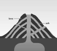
VULCANISM / VULCANICITY
Vulcanicity or volcanism is the range of processes by which molten materials and gases are either intruded (injected) or extruded (ejected) into the earth’s crust or into the earth’s crust respective Vulcanicity is the formation of various feature due to the intrusion or extrusion of molten materials, and gases. The molten materials are called magma when found within the earth’s crust and magma when poured on the earth’s crust.
Vulcanicity therefore includes volcanic eruptions, which lead to the formation of volcanoes and lava plateaus and geysers, and the formation of volcanic features such as batholiths, sills and dykes, etc, in the earth‘s crust.
There are two types of vulcanicity namely:
a) Intrusive Vulcanicity
b) Extrusive Vulcanicity
A. INTRUSIVE VOLCANIC FEATURES
This is when magma intruded within the earth’s interior. The features resulted due to the intrusive volcanic eruption is called intrusive features. The intrusive volcanic features are the features which are found within the earth’s interior. These include the following.
1. Dyke
This is a wall of rock which cuts across the bedding planes. It is formed when magma cools and solidifies vertically across bedding planes. Examples of dykes are Mwadui dyke in Tanzania, Gabbro dyke in Lesotho, and Tyolo dyke in Malawi.
 |
| Dyke |
2. Sill
This is a rock sheet formed when the magma solidifies horizontally along the bedding plane. It is concordant with the rock strata. Eg: Kinkon Falls found Fouta Djallon ranges in Guinea.
 |
| Sill |
3. Laccolith
This is an intrusive feature which looks like a dome. It is formed when the magma cools and solidifies in anticline bedding plane. It looks like a mushroom. E.g: Morafanobe in Madagascar.
 |
| Laccolith |
4. Lopolith
This is a saucer-shaped mass of rock formed in the geosyncline. The saucer-like shape may be due to the increased weight of the deposits. E.g: The Bushveld Basin in the Transvaal in South Africa.
 |
| Lopolith |
5. Phacolith
It is a lens shaped strip of igneous rock formed when the magima solidies along the anticline or syncline. Eg: Cordon wills in U.K
 |
| Phacolith |
6. Batholith
It is the large mass of solidified rock formed when magma cools plutonically at the great dept Eg: at the heart of the mountain ranges. Eg:- Chilu Batholic in Gabon
 |
| Batholith |
B. EXTRUSIVE VOLCANIC FEATURES
These are the features formed when the magma cools and solidifies on the earth’s surface. The following are landforms due to extrusive vulcanicity:
1. Ash and Cinder Cone (Scorio Cone)
It is a cone shaped accumulation of rock fragments around the vent. The slopes of the cone are always concave due to the spreading tendency of lava at the base of the cone. E.g: Busoka and Bitale in South West Uganda.
 |
| Ash and Cinder Cone |
2. Composite Cone (Strato Volcano)
It is a large cone with alternate layers of pyroclasts (fragments) i.e. ash and cinder on the other hand. E.g: Mount Kilimanjaro, Meru in Tanzania, and Virunga ranges in Uganda.
 |
| Composite Cone |
3. Volcanic Plug (Plug Dome Volcano)
It is a rigid cylindrical plug formed when very viscous lava is forced out by very explosive eruptions. The plug is extruded amid clouds of hot blowing ash and cinders. E.g:Hoggar Mountains in Algeria.
 |
| Volcanic Plug |
4. Acid Lava Cone (Cumulo Dome Volcano)
It is a dome shaped volcano with convex slopes formed when acidic lava solidifies around the vent.. E.g: Ntumbi Dome located in East of Mbeya, Tanzania.
 |
| Acid Lava Cone |
5. Crater
It is a depression formed on the summit of the cone after the plug has been
 |
| Crater |
6. Caldera
It is a large crater (large rounded depression) formed when the upper par of the volcano is either bombarded away by violent eruptions or subsides into the crust or in the volcanic cone. E.g: Ngorongoro in Tanzania, and Eboga Crater in Cameroun.
 |
| Caldera |
Minor Volcanic Features
1. Geyser
Geyser refers to the forceful emission of hot water and steam from the ground to a high level in the air. The ejected water contains fine materials such as volcano mud, which later form fertile soils. Geysers are found in Iceland, North Island and New Zealand.
2. Hot Spring
Hot spring refers to natural outflow of superheated water from the ground. It contains mineral substances in solution. Hot springs are found in Iceland, in Europe; and Kenya and Ethiopia, in Africa. Hot springs are also found in Manyara National Park, Songwe, in Mbeya and in Nigeria.
 |
| Geyser and Hot Spring |
Classification of Volcanic According to Activity
1. Active Volcano: is the volcano which erupts frequently. Eg:- Oldonyo Lengai in Tanzania and Mount
Cameroon.
2. Dormant Volcano is the one which has stopped erupting but not extinct and it is expected to erupt. The dormant volcano is also known as sleep volcano.
3. Extinct Volcano. Is the volcano which has stopped erupting for a very long time in history and is not expected to erupt. It is also known as
dead volcano.
Influences of Volcanic Eruption to Man and Environment
The following include the economic importance of volcanic eruptions to man.
1. Lava on weathering head to the formation of very fertile soil which support agriculture. The larva poured onto the earth‘s surface following vulcanicity forms a fertile soil upon weathering. This soil supports agriculture as well as forestry. Examples of fertile volcanic soils that resulted from volcanic activities are the rich acidic soils on the slopes of mounts Kilimanjaro, Kenya and Elgon, which supports the growth of coffee, banana, tea and other crops.
2. Volcanicity eruption lead to the formation of mineral deposits like copper deposits of butte in USA, diamond of kimberley in South Africa. Vulcanicity brings minerals from deep the earth‘s crust to close or onto the earth‘s surface. Various minerals and gemstones are mainly found in the volcanic regions. Diamond in Mwadui is mined from the volcanic plugs and dykes. Gold and silver are associated with the Nyanza batholith in Kenya.
3. Volcanic eruption provide geothermal power for electric generation. Geysers can be harnessed to generate geothermal electricity. Geothermal power is tapped from geysers in volcanic regions. In East Africa, geothermal power stations are established at Olkaria near Naivasha in Kenya.
4. Some hot springs utilized for heating homes in glaciated region. People use hot springs and pools of hot water as spas. They bathe in the water for the purpose of curing certain diseases. Hot water from hot springs is pumped into homes during winter to heat up homes. This is done in cold countries like Iceland and New Zealand.
5. Volcanic features attract tourist. Spectacular features formed upon vulcanicity such as mountains, calderas, caldera lakes, cones, geysers and hot springs are interesting to look at. As such, they attract tourist and hence earn foreign currency to the country.
6. Construction activities. When the magma solidifies, it forms hard rocks that can be quarried and used to construct roads, bridges, houses and other infrastructures.
7. Some crater lakes are a source of salts and other minerals while others support fishing activities, for example Lake Chala. Some lakes are a source of fresh water for domestic and industrial uses.
8. Volcanic cones are the source of rivers.
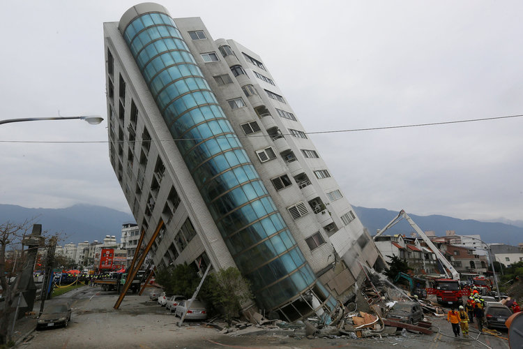
EARTHQUAKE
Earthquakes refer to the sudden shaking or vibrations of the earth’s crust due to sudden and rapid displacement of tectonic plates along the line of weakness (faults). It occurs mainly in volcanic eruption zones. The point from which the earthquake originates is known as focus and the intensity of earthquakes can be measured by using an instrument called seismograph. The point on the surface vertically above the focus is called epicentre
Measurement of Earthquakes
The intensity and magnitude measure the strength of the earthquake. These are obtained by detecting the Seismic waves using instruments called seismograph or seismometer.
Intensity is a measure of how hard the earthquake shakes the ground. It is determined through the effects produced by the earthquake. Intensity varies from one place to another. While the intensity of a specific earthquake varies, its magnitude does not vary. So it is important not to confuse magnitude with intensity.
The scale that measures the intensity is called Mercalli scale. It ranges from undetectable, moderate, strong to major catastrophe. Magnitude refers to the total amount of energy released and it is given on the Ritcher scale. This scale ranges from 0 to 8.9.
 |
| Earthquake |
Causes of Earthquakes
1. Faulting of the lithosphere caused by tectonic movement where one plate slides over another plate.
2. Volcanism can cause occurrence of the earthquake. This is because the magma moves under the influence of intense pressure from within the earth’s interior.
3. Mass wasting like land slide and rock fall can cause occurrence of earthquake, but this is for local scale.
4. Falling objects from the atmosphere such as meteorites may lead to the shaking earth’s crust.
5. Man’s influence through his activities such as mining using explosives like dynamites and transport vessels like trains and heavy trucks.
Types of Shock Seismic Waves Generated during the Earthquake
Seismic waves can be categorized into broad groups as follows:
1. Body Waves. Are waves which travel through the crust and are of two types:
a) Primary Waves, which cause the crustal rock to move back and forth in the direction of wave movement
b) Secondary Waves. Are waves which cause the crustal rock to move side to side ie right angles to the direction of wave movement.
2. Surface Waves. These travel through the surface and are of two types:
a) Love Waves. Which cause the surface rock to move side to side of right angles to the direction of wave movement.
b) Rayleigh Waves. Wave which cause the surface waves to have a circular movement very similar to that of water wave movement.
Effects of Earthquakes
1. They can cause loss of life and property. An earthquake is a natural disaster. Whenever it occurs, it causes a lot of disturbances including loss of life and properties. For example, the earthquake that hit Toro in Uganda in 1966 killed 157 people, injured about 1300 people and destroyed about 6000 houses. The earthquake which occurred in California–Mexico border in 1975 caused damage running into millions of dollars and injured 100 people on both sides of the border where most of them suffered cuts from flying glass and debris.
2. They can displace parts of the earth’s crust vertically or laterally.
3. They can raise or lower parts of the sea floor. The Agadir earthquake in Morocco in 1960 raised the sea floor of the coast. In some areas the depth of the sea decreased from 400 m to 15 m after the earthquake.
4. They can raise or lower coastal rocks. In the Alaskan earthquake of 1899, some coastal rocks were raised by 16 m.
5. They can cause landslide and open up deep cracks in the surface rocks. The El Asnam earthquake in Algeria, in 1954, destroyed an area of radius 40 km and opened up deep cracks up to 3 m deep.

Precautionary Measures to Avoid high Damage from Earthquakes
1. Refraining from building high-rising structures on the land vulnerable to earthquake as well as strengthening buildings by using reinforced concrete, steel frames, deep foundations and light roofs.
2. Geologists should detect epicentres and tell the people to evacuate the places likely to be affected by earthquakes.
3. To avoid constructing very large water bodies like Kariba dam which can cause the earthquakes due to the weight of water and other materials.
4. Discouraging the use of explosives like dynamites in breaking the rocks during mining and construction operations.
WEATHERING
Weathering refers to a processes where by rocks disintegrate into small particles due to the agents of weathering such as water, ice, wind, wave, etc. The process results from the forces of weather, that is, changes in temperature, frost action and rain action.
Types of Weathering
The main forms of weathering include:
1. Mechanical weathering;
2. Chemical weathering; and
3. Biological weathering.
1. MECHANICAL WEATHERING
This is also referred to as physical weathering. It is a type of weathering caused by changes in temperature. It is common in areas where there are extreme changes in temperature such as hot deserts, arid and semi arid regions. Mechanical weathering includes the following types:
1. Exfoliation
This process occurs due to temperature change. During the day time rocks expand due to high temperatures and contract during the night due to low temperatures. Alternate heating and cooling set up powerful internal stress in the top layer of the rocks. The stress produces fractures which cause the outer layer to pull away leading to the cracking and disintegration of rocks into small particles.
The rocks that remain standing as exfoliation takes place are called exfoliation domes. Exfoliation domes occur in desert, semi-desert and monsoon regions. There are many exfoliation domes in the Egyptian, Kalahari, Sahara and Sinai deserts.
 |
| Exfoliation |
2. Granular Disintegration. It is the breaking up the rock which consists of different minerals. These minerals expand and contract separately through temperature changes.
 |
| Granular Disintegration |
3. Block Disintegration. This takes place when the rock with homogeneous rock breaks into rectangular blocks due to changes in temperature. This is common when the rock is jointed . this process can be aided by chemical weathering.
 |
| Block Disintegration |
4. Frost action
This is common in temperate regions where temperature falls up to freezing point. When temperature falls (freezing point) water collects in the rocks and it freezes, its volume increases causing the crack to deepen and widen. Usually it involves the freezing of water in the cracks during the night and thawing (melting) during the day in mountainous areas. This action of thawing (melting) and freezing of water in the cracks cause the rocks to shatter (break) into angular fragments.
 |
| Frost Action |
2. CHEMICAL WEATHERING
Chemical weathering involves the decomposition of some of the minerals contained in a rock. Some rocks decompose when they come into contact with water (H2O), or oxygen (O2) and carbon dioxide (CO2), two of the gases that make up air. Chemical weathering includes the following processes:
1. Oxidation – This happens when oxygen combines with a mineral. It takes place actively in rocks containing iron, when oxygen combines with iron to form iron oxides. This process is often preceded and accompanied by hydrolysis. The new minerals formed by oxidation are often easily attacked by other weathering processes.
2. Carbonation – This process occurs when hydrogen carbonate ions react with a mineral to give a soluble compound which can be carried away in solution. Hydrolysis often accompanies carbonation.
3. Solution –This refers to dissolution of a mineral with a chemical substance. Rain water combines with both atmospheric carbon dioxide and oxygen to form weak carbonic acid. CO2(g) + H2O(l) → H2CO3(aq).So when the rain reaches the ground it consists of a weak acid called weak carbonic acid. This acid helps to dissolve many insoluble minerals into minerals soluble in water, and which can be carried away in solution.
When rain containing weak carbonic acid falls in a limestone region, it reacts with limestone (calcium carbonate) and dissolves it into soluble calcium hydrogen carbonate, which can easily be carried away in solution.CaCO3(s) +H2CO3(aq) → Ca(HCO3)2(aq). In limestone regions, the rocks are dissolved and produce features like grike andclint(trough and ridge).
When rain containing weak carbonic acid falls in a limestone region, it reacts with limestone (calcium carbonate) and dissolves it into soluble calcium hydrogen carbonate, which can easily be carried away in solution.CaCO3(s) +H2CO3(aq) → Ca(HCO3)2(aq). In limestone regions, the rocks are dissolved and produce features like grike andclint(trough and ridge).
3. Hydration – This is the process in which some minerals absorb water and swell up, causing internal stress and fracture of the rocks.
4. Hydrolysis – This process involves the reaction of hydrogen (in the water) with certain mineral ions (in a mineral). This gives rise to the formation of different chemical compounds that can be easily weathered through other weathering processes.
NOTE: Usually two or more chemical weathering processes take place at the same time. Chemical weathering is most marked in hot wet regions.
3. BIOLOGICAL WEATHERING
When plants grow on rocks, their roots penetrate into rock joints which later force the rocks to break apart. Also man contributes much to rock disintegration through farming activities, mining, quarrying and construction. Macro- and microorganisms also disintegrate rocks through burrowing and by mineralization process. Bacteria, for example, in the presence of air, break some minerals which are dissolved in the soil. Plants also absorb minerals from the soil by their roots. Decayed vegetation produce organic acid which remain in the soil. All of these actions help to weaken the rocks.
 |
| Disintegration of Rocks caused by Plants |
Factors Which Control the Rates of Weathering
1. Rock composition: There are certain elements which are included in rock composition. Some rocks will weather quickly and some slowly e.g. acidic rocks weather more quickly than basic ones.
2. Climate: It includes the meteorological elements effect on rocks such as moisture, temperature, and wind and air pressure. Climate determines whether physical or chemical weathering will be more active and speedy.
3. Topography and Vegetation: Topography directly effects weathering by exposing rocks to the temperature or sun and wind. The elevated areas will be affected more and low level areas will be affected less.
4. Vegetation: Surface covered by the vegetation are protected from weathering but bare surfaces are weathered to great extent.
- Thin root plants protects weathering
- Thick root plants accelerates weathering
5. Length of Exposure: The longer a rock is exposed to the agents of weathering, the greater the degree of alteration, dissolution and physical breakup. Lava flows that are quickly buried by subsequent lava flows are less likely to be weathered than a flow which remains exposed to the elements for long periods of time.
 |
| Disintegration of Rocks caused by Human Beings |
The Significance of Weathering
1. Weathering leads to soil formation. Soil is formed through the process of weathering of rocks. Various forms of weathering lead to rock disintegration and hence formation of the soil. The soil is an aggregate of organic and inorganic particles formed by different processes of weathering.
2. Weathering may shape the rocks into attractive features whichcan attract tourists and hence earn the country and communities the much needed foreign exchange. An example of a feature that can attract tourists is the Bismarck Rock on the south shore of Lake Victoria.
3. The processes of weathering weaken the rocks such that they can be easily acted upon by agents of erosion. The process helps to shape the earth and produce various landforms. This, in turn, influences the type of human activities that can take place in an area. So the process is very important in supporting life.
4. When the rocks are weathered they become weak and hence easy to exploit, e.g. by quarrying. This process also helps to break up large rocks into small fragments such as sand, which is used for construction purposes.
5. Weathering serves as carbon sink. Any process that reduces the amount of carbon dioxide from the atmosphere is termed as carbon sink. Some processes of weathering involve absorption of carbon dioxide from the atmosphere. This helps to remove excess carbon dioxide from the atmosphere. Limestone and other carbon-based sedimentary rocks are important carbon sinks.
MASS WASTING
Mass wasting is the movement of the weathered materials downslope due to gravitational forces accompanied by rain action. Mass wasting also known as slope movement or mass movement
Types of Mass Wasting
Types of mass movement are distinguished based on how the soil, regolith or rock moves down the slope as a whole. Based on this factor, mass wasting can be categorized or grouped into two types. These are:
1. Slow Movement
2. Rapid Movemen,
Each with its own Characteristic Features
and taking place over timescales from seconds to years.
1. SLOW MASS MOVEMENT
This is the movement of soil at very slow speed, water acting as the lubricant. Slow mass wasting is categorized into several types.
These are as follows:
a) Soil Creep. Soil creep is the slow movement of the soil downhill after it gets soaked by water. This process is very slow and its evidence is provided by tilting of trees and falling of buildings and fences. Soil creep is activated by any process that loosens the soil, making it easy to move gradually down the slope.
 |
| Soil Creep |
Factors Influence Soil Creep:
1. Alternate heating and cooling of the soil particles.
2. The freezing of water in the soil causing frost heaving.
3. Removal of the soil further down the slope.
4. Percolation of water into the soil, acting as a lubricant.
5. Ploughing of the soil, a fact which makes the soil loose and more mobile.
b) Talus Creep. It takes place due to the processes of thawing and freezing and is more pronounced in high latitude regions. It is very common on sides of mountains, scarps and valleys. This is also a very slow mass movement of screes. Rock creep It occurs commonly where individual rock blocks are lying over clay materials. In the presence of moisture, the clay surface becomes slightly slippery. The rock blocks may creep slowly down the slope under the influence of gravity. Individual rock blocks may move very slowly down a slope.
 |
| Talus Creep |
c) Solifluction. This is the slow movement or flowing of weathered materials, especially when mixed with water and gravels. It is limited on highlands and cold regions.
 |
| Solifluction |
2. RAPID MASS WASTING
This involves the movement of materials in form of mud flow, land slide, rock fall and earth flow.
a) Earth Flow. This type of movement occurs in humid regions. The materials on the earth’s surface gets so saturated with water that it gains much weight, and starts to move down the slope under the influence of gravity. This normally occurs on the slopes of the hills or mountains. The removed earth material leaves a shallow scar on its place of origin and it creates terraces or mounds in its destination.
 |
| Earth Flow |
c) Mudflow. Mudflow is the movement of a large mass of unconsolidated rocks down the slope when saturated with water. It flows in semi liquid state. It is common in desert slopes, which are not protected by a cover of vegetation. This occurs, for instance, during a torrential storm when more rain falls than the soil can absorb.
 |
| Mud Flow |
d) Avalanches. It is a sudden and catastrophic movement of a wide variety of materials down slope associated with snow. The movement can take a flow or sliding or falling form.
 |
| Avalanche |
e) Land Slide .This is the rapid movement of surface rocks and soil down a steep slope such as a cliff face. It includes slumping and sliding of materials. During the movement, the block tilts and leaves holes. It is common in well jointed limestone rocks, shale or clays. The common forms of landslides are slump, debris slide, rock slide, rock fall, debris fall and avalanche.
 |
| Land Slide |
f) Rock Fall. This is the free-falling of a single mass of rock, common on steep slopes of mountains and along scarp slopes of the sea. This is the most rapid of all mass movements. If a rock fall occurs repeatedly, for a long time, the broken rocks collect at the bottom of the slope in a mound called talus.
 |
| Rock Fall |
The Factors which Cause Mass Wasting
Mass wasting is caused by a number of factors which include the following:
1. Gradient or slope: When the gravitational force acting on a slope exceeds its resisting force, slope failure (mass wasting) occurs. Mass wasting is very common and severe in areas with steep lands as compared to flat or moderately flat lands.
2. Weathering: weathering processes weaken and loosen the rock, hence accelerating the process of mass wasting. For example, oxidation of metallic elements and hydration of the minerals in rocks create lines of fracture and, consequently, the onset of mass wasting.
3. Amount of water present in the rocks: Water can increase or decrease the stability of a slope depending on the amount present. Small amounts of water can strengthen soils because the surface tension of water increases soil cohesion. This allows the soil to resist erosion better than if it were dry. If too much water is present the water acts as lubricating agent, reducing friction, and accelerating the erosion process, resulting in different types of mass wasting (i.e. mudflows, landslides, etc.)
4. Vegetation: The roots of plants help bind the soil particles together making the soil resistant to agents of erosion and weathering. This makes the soil hard to break and hence resistant. Mass wasting processes, such as soil creep, cannot occur easily in soils well-covered with vegetation. Also the mass of vegetation cover blocks and prevents movement of the eroded material. Plants remove water from the ground through absorption. There for absence of vegetation accelerates mass
wasting.
5. The nature or type of the rock materials: Clay soil is compact and resistant to various types of soil erosion agents and mass wasting as compared to sandy soil, which is normally loose and easy to remove and transport by water, gravity, wind, etc. Thus, mass wasting may be more severe on sandy soil than its counterpart clay soil under similar prevailing conditions.
6. Overloading: When the soil accumulates in one location as a heavy mass of the rock material, it can be moved either by action of gravitational force or application of just a little force. Landslides occur as a result of the soil accumulated on a sloping land to an extent of exceeding the resistant force of gravity. Movement occurs when the gravitational force exceeds the resistant force of soil material.
7. Earthquakes: Earthquakes cause sections of the mountains and hills to break off and slide down. Earthquake tremors tend to loosen the soil material and make it easy to be removed and transported. It can accelerate rock falls, landslides and soil creeps.
8. Human activities: The activities of man such as cultivation, burning, mining, transportation, animal grazing, etc, removes the soil cover or leads to shaking of the soil.
9. Climate: Climate has a great influence on mass wasting. Areas that receive heavy rains often experience mass movements, such as landslides and soil creep, more often compared to dry areas. On the other hand, a little amount of rainfall does not wet the soil and so cannot cause the soil to move. In cold regions, alternate freezing and thawing triggers mass wasting.
10. Vulcanicity: Volcanic activity often causes huge mudflows when the icy cover of a volcano melts and mixes with the soil to form mud as the magma in the volcano stirs preceding an eruption.
 |
| Mass Wasting caused by Erupting Volcano |
The Effects of Mass Wasting to the Environment
1. Formation of scars and bare land: When a large mass of soil moves, such as it occurs in landslide, the process leaves behind a large portion of eroded, bare and unproductive land. This land is often not easily colonized by plants, a fact which stimulates further erosion on the bare scar. Scars are very common on slopes of mountains such as mounts Kilimanjaro, Kenya and Rwenzori.
2. Soil erosion: When mass movement takes place, the load often removes almost all the vegetation on its way. This exposes the land to agents of erosion such as wind, animals, water, ice, waves, etc. Also the place from which the material has been removed forms a scar upon which water, ice and other agents of erosion can act and remove the soil, further leading to gullies, depressions and gorges.
3. Formation of new landforms: The materials removed and transported to a distant location may form hills at their destination and form scars and depressions at the place of origin.
4. Formation of lakes: Materials of landslide can block ariver bedand valley, preventing downward movement of water. The blocked water accumulates on the upper side of a river valley to form a lake. Examples of such lakes include Lake Bujukuin theRwenzori Mountains, Nyabihoho in Uganda and Funduziin South Africa. Lake San Cristobal in Colorado, USA, was formed when mudflow dammed (blocked) a river in the San Juan Mountains.
5. Diversion of a river course: The landslide material can block the natural river bed, forcing the river to divert and form a new route. This makes the river leave its usual flowing course, and form a new course. The direction of flow of the river is thus changed. This happened in the Rif Atlas Mountains of Morocco in 1963 when a mudflow pushed the course of RiverRhesana100 metres to the east.
6. Formation of a fertile soil: If the removed material comes from a fertile land, it can form a fertile soil at the place of destination, where fertile soil never existed, and encourage agricultural activities to take place.
7. Damage to property: Different categories of landslides may cause various damages to property and can adversely affect other resources. The effects of landslide are dangerous because they destroy everything in their path. Roads are blocked, hampering traffic flow. Homes, buildings and other infrastructures are destroyed. The water mains, sewers and power transmission lines are disrupted. Oil and gas production and transportation facilities are ruined. Farms are also destroyed by various forms of mass wasting.
8. Loss of life: The more populations expand and occupy more and more of the land surface, mass movement processes become more likely to affect humans.
RIVER AND RIVER SYSTEMS
River refers to a mass of water flowing through a definite channel over a landscape from river source to river mouth. River source is the place where a river starts. It may be in the melt water from glacier e.g. river Rhome (France), a lake, e.g. Lake Victoria, the source of river Nile, a spring e.g. Thames (England) or it can be formed following steady rainfall e.g. river Congo. River mouth can be anywhere a river pours its water, e.g. a lake, ocean or sea.
 |
| River |
How Agents of Erosion and Deposition Operate on the Landscape
The river has three functions as it flows through its channel. These are river erosion, transportation and deposition.
1. RIVER EROSION
Erosion of a river operates in three ways, that is, head ward, vertical and lateral erosions.
a) Head ward erosion – this is the cutting back of the river at its source. It is through this erosion that a river increases its length.
b) Vertical erosion – this is erosion by which a river deepens its channel.
c) Lateral erosion – This is the wearing away of the sides of a river by water and its load. It is responsible for widening of a river valley.
River erosion involves four related processes. These are abrasion (corrasion), attrition, corrosion (solution) and hydraulic action.
1. Hydraulic Action: This is the process whereby the force of moving water plucks and sweeps away loose materials, such as silt, gravel and pebbles. Materials plucked by hydraulic action are responsible for bank caving and slumping.
2. Corrasion (abrasion): This is when the load of the river rubs against the bed and sides of the river channel. This causes wearing away of the sides and bed of the river. The amount of load determines the nature of erosive power and rate of erosion. This is a source of pot holes in the river bed.
3. Attrition: This is when the rock fragments in a river’s load are broken into small fragments due to collision against one another as the load is carried downstream along the river channel. As the river moves along its course, its fragments get progressively smaller because of disintegration and wearing away.
4. Corrosion (solution): River water dissolves certain minerals leading to dissolution and disappearance of some rocks, e.g. limestone, rock salt and chalk.
 |
| River Erosion |
2. RIVER TRANSPORT
This is the process which involves carrying away of the weathered and eroded, loose materials from one place to another. The materials carried out by river is called load. River transports its load in four ways:
1. Saltation – this is the process in which small pieces of the rock fragments are carried by a river while bouncing on the river bed.
2. Traction – this is the dragging or rolling of large boulder such as pebbles along its river bed.
3. Suspension – This involves transport of fine or light materials like silt and mud, which are carried in suspension forms. This is common when the river flow is too strong.
4. Solution – this involves moving some materials that dissolve in water, which are carried away in solution form. A river transports its load until it has insufficient energy to transport it any further.When this happens, the load is deposited.
 |
| River Transport |
3. RIVER DEPOSITION
A river deposits its load when its volume and speed decrease.
a) A river volume decreases when:
1. It enters an arid region especially a hot desert;
2. it crosses a region composed of a porous rocks e.g. sand and limestone; and
3. During the dry seasons or in a period of drought.
b) A river speed decreases when:
1. it enters a lake or sea; or
2. when it enters flat or gently slopping plain such as a valley bottom.
Deposition takes place when the river has insufficient energy to carry its entire load. The first part of the load that is dropped consists of boulders and pebbles. The last part to be dropped is the fine sediment, called silt. Deposition takes place at any point in a river’s course.
 |
| River Deposition |
THE LONG PROFILE OF A RIVER
The long profile of a river is the line following the course of a river from its source to its mouth. Three courses or sections of a river can be distinguished.
These are:
1. The upper course.
2. The middle course.
3. The lower course.
 |
| Long Profile of the River |
1. THE UPPER COURSE
This is the first stage of a river. It is sometimes called the youth or torrent course.
Its characteristics are as follows:
1. It is the river source.
2. The speed of a river is high.
3. Most of the works of the river include vertical erosion.
4. The cross-section of a river valley in this section of a river is V–shaped.
5. The slope of a profile is very steep.
6. It is sometimes utilized for hydroelectric power (H.E.P) generation. Erosional and
 |
| Upper Course of the River |
Depositional Features for Each Agent
The main features of the upper section are deep and narrow, V-shaped valley; a steep gradient; pot holes on the river bed; interlocking spurs and waterfalls and rapids, often with plunge pools.
1. V–shaped valley: this is a deep, narrow valley at youth/first stage of a river.
2. Pot holes: These are circular depressions on the river bed. They are formed when pebbles carried by the swirling water cut circular depressions in the river’s bed.
3. Interlocking spurs: An interlocking spur, also known as an overlapping spur, is one of any of a number of projecting ridges that extend alternately from the opposite sides of the wall of a young, V-shaped valley down which a river with a winding course flows.
Each of these spurs extends laterally into a concave bend of the river such that when viewed either upstream or from overhead, the projecting ridges, which are called spurs, appear to "interlock" or "overlap" in a staggered formation like the teeth of a zipper. As the river erodes the landscape in the upper course, it winds and bends to avoid areas of hard rock. This creates interlocking spurs. Waterfalls and rapids:
4. Waterfall: A waterfall is a place where water flows over a vertical drop in the course of a stream or river. A waterfall is formed when there is sudden change or drop in the bed of a river. Although waterfalls can occur in almost any part of a river’s course, they are most common in the upper course. Examples of waterfalls are Owen Falls in Uganda, Victoria Falls in Zimbabwe and The Livingstone
5. Rapids: These are sections of a river where the river bed has a relatively steep gradient, causing an increase in water velocity and turbulence. Rapids are characterised by the river becoming shallower with some rocks exposed above the flow surface. As flowing water splashes over and around the rocks, air bubbles become mixed in with it and portions of the surface acquire a white colour, forming what is called "whitewater". Rapids occur where the bed material is highly resistant to the erosive power of the stream in comparison with the bed downstream. Very young streams flowing across solid rock may be rapids for much of their length.
6. Plunge Pool: This is a large depression formed at the base of a waterfall.
7. Gorge: It is a steep, narrow and elongated valley. A gorge often is formed when a waterfall retreats upstream, e.g. a gorge found in Victoria Falls.
 |
| Upper Course of the River |
2. THE MIDDLE / MATURITY STAGE
This is the second stage of a river. The main features of this section are bluffs and waterfalls and rapids.
The Characteristics Features of the Middle Course of a River Valley
1. The speed of a river is fairly low.
2. Most of the work of a river is transportation.
3. The cross–section of a valley in this section is an open V.
4. The slope of a relief is gentle
5. The volume of a river increases.
6. Lateral erosion predominates.
 |
| Middle Course of the River |
Features Associated with the Middle course of a River Valley
1. Bluffs: These are steep slopes of the truncated spurs in middle course where interlocking spurs turn into bluffs.
2. Waterfalls and rapids: Waterfalls and rapids can also be found in the middle stage of the river valley. This is mainly caused by river rejuvenation which increases erosive activity and transportation, hence development of waterfalls.
3. THE OLD / LOWER STAGE
Third is the third stage of a river. The main features of the lower section of a river valley are a flood plain; braided river; ox-bow lake; levee and deferred tributary and delta.
Characteristics of Lower Stage
1. It is the river mouth.
2. Always there are gradient falls or slope falls.
3. The main work of a river is deposition.
4. The cross–section of a valley is a U–shaped valley.
5. The speed of a river is decreased.
6. The river valley is very wide.
 |
| Lower Course of the River |
The Importance of Erosional and Depositional Features to Human Beings
1. Loess form very fertile soil in desert land,
2. Water falls attract tourists; headlands in coastal areas are natural ports.
3. Coastal features form breeding places for fish,
4. Coral reefs are used as building materials and for settlement.
ARTIFICIAL FORCES
These are forces that are caused by human beings through their activities such as farming, mining,
setting up settlements,
road construction, transport, etc.
Man can influence in destruction or removal of some parts of the earth’s surface.
This shows that man can modify natural landforms and, therefore, acts as the agent of weathering,
mass wasting,
erosion,
transportation and
deposition on the earth’s surface.
Human modification of the land helps loosen large chunks of earth and cause them to slide downhill.
Man Produces Forces that Affect the Earth through the following Activities:
1. Removing vegetation: A slope with lots of vegetation is less susceptible to mass movement than a bare slope. Bare, exposed soil is very easily eroded, and can contribute to mass movement activity.
Vegetation: helps hold soil, loose rock, and regolith together by its roots; reduces the direct erosive impact of rainfall and other precipitation; actively reduces ground moisture by using it to contribute to plant growth; and produces litter and organic products (leaves, twigs, grasses, fruits) that help stabilize the soil.
2. Mining: In the course of mining, man uses machines to dig the soil and blast rocks. These activities results to earth tremors which loosen the soil particles making then vulnerable to removal by agents of weathering and denudation. Blasting also causes fractures in rocks, a fact which makes them less stable and resistant to shear and stress. If this happens, especially on steep slopes, the probability of occurring landslide is very high.
3. Farming activities: Farming involves digging the soil by using farm implements such as hoes, tractors, harrows, spades, etc. These activities involves breaking up the soil and rocks by the implements. In this way, crop cultivation directly leads to weathering and erosion.
Overstocking - (keeping many animals in just a small piece of land) also leads to soil erosion. This is because overstocking is usually accompanied with overgrazing, an act which removes the vegetation cover. This triggers soil erosion and other weathering processes.
4. Building and construction: Breaking up the soil for construction of houses and other
infrastructures can dramatically increase the potential of mass movement. These processes involve tearing rocks to get room for setting up infrastructures such as roads, railways, airports, seaports, etc. This leads to destruction of the soil, hence triggering mass movement, weathering and erosion.
5. Fishing: Fishermen in less developed countries sometimes use weapons such as dynamites to kill and catch fish. Tremors produced by these illegal fishing tools can cause fracturing of the coastal rocks. This causes both weathering and erosion.
6. Navigation: In some few cases, marine vessels accidentally crush onto stones in water, peeling or breaking then into pieces. This leads to rock disintegration, a typical form of weathering.
7. Transport: Vibrations from machinery, traffic, weight loading, stockpiling of rock or ore from waste piles and from buildings and other structures loosen the soil and make it prone to soil erosion and weathering.
8. Construction of dams and canals: Construction of dams, such as the Mtera dam in Tanzania and canals such as the Suez Canal in Egypt, involves removing a large junk of rock. This breaks up the soil, leading to weathering and soil erosion.
9. Warfare: The use of atomic bombs and other heavy weapons in war leads to destruction of the soil. During times of war, heavy and destructive weapons such as atomic bombs, shells, rockets and grenades are dropped or fired towards the enemy. When these weapons fall on land, they detonate and blow up a large mass of the earth, causing weathering and erosion. Military equipment such as tanks, heavy trucks and caterpillars break up rocks over which they pass. At the same time, they loosen the soil and carry away some of it as they move along.
 |
| Mining |
The Effects of Artificial Forces
Apart from the effects caused by natural forces that affect the earth, man-made (artificial) forces have an effect of creating artificial landforms and features on the earth’s surface. These include the following features:
1. Man-made lakes such as LakeCahoraBassain Mozambique, Lake Volta in Ghana, LakeKaribain Zambia (the world's largest artificial lake and reservoir by volume) and Lake Nasser in Egypt.
2. Man-made rivers in the form of canals such as Suez and Panama Canals. 3. Wells and boreholes
4. Roads, harbours, railways, airports, bridges, etc.
NOTES 2


EmoticonEmoticon